Scafell Pike is the highest mountain in England, standing proud in the Lake District National Park at 3,210 feet. Although it is not my favourite peak (far from it in fact), I have walked up it four times.
The first time was when I was still at university, in 1993. I always remember this climb, because we were in the snow, above the clouds. To someone who had never experienced this before it felt as if we were in the Himalayas, standing above distant peaks trying to break through in the distance. It was truly spectacular, and it took me until late 2017 (in fact only a few days prior to writing this post) to be lucky enough to have a similar experience. My next ascent was in 1996, when I completed the Three Peaks Challenge with some work colleagues. The Three Peaks involves climbing the highest peaks in Scotland, England and Wales (Ben Nevis, Scafell Pike and Snowdon) in under 24 hours. We ran down the last part, finishing with half an hour to spare. Exhausted, we all sat down in Snowdon’s car park, and after 10 minutes found we couldn’t get back up again because our muscles had seized up. As we groaned and laughed and tried to straighten ourselves other walkers looked on with disapproval. Not realising we had just finished a mammoth walk, they thought we were doubled up after little more than an after-lunch stroll!
We were lucky with the weather; Ben Nevis in particular was completely clear. As I gazed out over the other Munros trying, but failing, to match Ben Nevis in height, I really did feel on top of the world.
 I don’t have a photo of Scafell Pike from that trip – I suspect we were too busy keeping our heads down and trying to beat the clock. The only other photo I have from that trip is at the bottom of Snowdon, after we had finished. We were in high spirits and someone suggested we strip off and posed “naked” behind our company banner. So it was that we appeared in the trade press and every now and again this photo comes back to haunt me.
 My third climb was four years later, in 2000, and with several of the team pictured above. It was absolutely scorching. Jonathan (centre in the photo with the hairy chest) said he had brought some sun cream with him, so nobody else bothered. Unfortunately it turned out to be after-sun lotion and not sun cream at all. As a result we all got burnt to a crisp, to the extent that I am sure my flesh had started to slide off my bones, and where I suddenly felt that the heat beating down on me was nothing to the heat my burnt body was giving off in return.
In an attempt not to make the sunburn any worse, we had to walk in long-sleeved shirts and trousers, wearing hats, neck warmers and gloves. Every one else was in T-shirts and shorts, and we got more than a few strange looks on such a searingly hot day.
So with four climbs, you see, when it comes to Scafell Pike I feel as if I have been there and done that.
As a result, when Deb and I took the kids to the Lake District for their first time I was not that bothered about Scafell Pike. My son Ben, however, most certainly was bothered. It was England’s biggest peak and therefore had to be climbed as soon s possible. So off we set again, this time via the Corridor Route.
The Corridor Route has a small nub of rock halfway along it. You have to scramble over this before continuing to a big scree slope which is the final challenge before the summit. The weather was fine and we made the top with ease. Mission accomplished. Ben was happy.

We descended the same way. Down the scree slope and back onto the Corridor Route. We were about half a mile from the nub of rock and had a clear line of sight down to it. My wife was talking to me and I was watching a large group of about 20 people at the foot of the rocks. The first of them had just started the scramble up and over. All of a sudden another of the group, looking up from the bottom, took a step back. He had clearly not realised that the path dropped away behind him. He lost his footing and tumbled over. I watched in absolute horror as he cartwheeled over and over, literally bouncing down the steep hillside below him. His arms and legs flailed out from his body as he spun round and round, seemingly bouncing higher each time he hit the ground. As he gathered momentum I saw he was headed towards an even steeper drop, which surely meant the worst possible outcome. However, just as he span towards the edge, he hit some rocks. This time he did not bounce. He stopped dead. He had fallen about 80 feet down a gradient of about 45˚. It seemed as if he had only touched the ground maybe five times during that fall.
There must have been five or six groups of people between us and him. At the time I remember thinking that their reaction was very strange. They all stopped where they were and did not continue any further. However, having thought about this I suppose it is a natural reaction. They could do nothing to help, but to just continue on their way? Walking callously on, right by someone who had just fallen and who must be injured? I think they found that unthinkable. Thus, they stopped where they were and just waited.
We didn’t stop. I had a GPS with me and realised I could assist with calling for help. We hurried passed the other people and got to the group with the injured man. I took a reading on my GPS and went up to a woman who was on her phone and trying to get through to Mountain Rescue. She had a connection but it kept cutting out; the line eventually went dead. I asked how the man was and she said it looked as if he had broken his arms and legs, and was also bleeding. But he was conscious. They had a doctor in their group who was performing first aid.
I gave her the coordinates and said I would continue on down, calling their exact location through to Mountain Rescue as soon as I had a signal.
Luckily I got a phone signal about 350 feet further on. I got through to Mountain Rescue, gave them the coordinates, and that was all we could do. We continued on down.
I was expecting to see a helicopter quite quickly, but in fact it was about 2 hours later, almost when we were back at the car, when we heard the distant chopping of the rotors. I realise now that Mountain Rescue had to send a ground team up first to assess the site and the man’s injuries. By this time the weather was closing in. That poor group! After waiting a couple of hours for the helicopter, I imagine they then must have had to make their descent in the pouring rain.
And as for the fallen man himself? I have no idea how he is today. Wasdale Mountain Rescue published an incident report which simply said:
“A man suffered serious injuries when he fell around 20 meters from the Corridor Route. He was treated by the team and flown to hospital by RAF Boulmer”.
 There are videos of him being winched up by the helicopter on Wasdale Mountain Rescue’s webpage, which you can see by clicking this link. But how the man is now I have no idea. His injuries were simply listed as “multiple”. I hope he is fully recovered now.
Experiencing this gave me a real appreciation of what Mountain Rescue do. To be ready to drop what you are doing at a moment’s notice and head out into the fells at any time of day or night is no small commitment. This is especially so when more than a few call-out’s are for missing persons who turn up safe and well a few hours later in a car park or pub. Although 34% of call-outs in 2017 were for medical reasons and injuries, another 34% were for people who were lost and 19% for people who were overdue. People who are lost can sometimes be talked down and so no call-out is necessary. The “overdues” tend to result in call-outs between 6pm and midnight.
In 2017 there were 140 incidents for Wasdale Mountain Rescue, of which 101 resulted in call-outs. In the peak months of July and August incidents came in at an average rate of nearly one a day.
And the members of Wasdale Mountain Rescue Team are volunteers. Hats off to them.
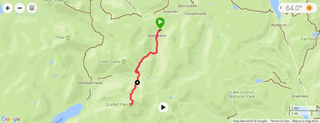
Points on this part of the walk (copy and paste the co-ordinates into Google Earth)
- Seathwaite (Parking and Start of Walk): N 54° 30.009′ W 003° 10.910′
- Summit of Scafell Pike: N 54° 27.254′ W 003° 12.699′
- Approx Location (from memory) of the Fall: N 54° 28.270′ W 003° 12.234′
Walk Statistics:

 And a little on the muddy side too.